It’s Monday and we are back in the Capitol building in Pierre, South Dakota, for day seven of the Keystone XL permit certification hearing.
Last week the hearings went through Saturday, with the extra day being added on due to the hearings taking longer than the commissioners had expected. With a six-day week, TransCanada’s patience started to run short, and this Monday morning it is clear their patience has entirely run out. Within the first few hours of the hearing, TransCanada objected to nearly every presentation and statement made by intervenors; it quickly became clear the objections were taking longer than the presentations themselves. Peter Capossela, representing the Standing Rock Sioux Tribe, pointed this out on numerous occasions.
The longer these proceedings go on, the more clear it becomes that this pipeline is not in the best interest of the state of South Dakota. More than that, and more specific to this hearing, it is eminently clear there is no way Keystone XL can meet the conditions of the original permit.
We are focusing this post on one particular issue that is of great concern to everyone in these proceedings, and should be of great concern to everyone in this state and beyond. Water.
Know this: According to Dr. Arden Davis, Geological Engineer and Professor at the South Dakota School of Mines, a spill from Keystone XL into the Cheyenne River could reach Lake Oahe within 12-24 hours. Also know this: The Keystone XL pipeline could leak 12,000 barrels in that 24 hours before the pipeline’s leak detection systems even kick in. That is 12,000 barrels of diluted bitumen in the water before it is detected. That is 378,000 gallons. In the water. Before they detect a leak.
And that is just one water crossing. There are over 300 planned crossings of water bodies for the Keystone XL pipeline, many of which directly or indirectly drain into the Missouri River. Even more troublesome (if that is even possible), much of the terrain crossed by the pipeline is highly permeable, meaning any land spill could very well leak down into our aquifers.
TransCanada argues their construction plans, their “safest pipeline” standards, and their spill mitigation efforts are enough to ensure the safety of our water. Dr. Davis testified today, however, that there is no way to completely mitigate the risks Keystone XL poses. So the essential question is, then, how much risk are we, as the citizens of South Dakota, being asked to take for TransCanada’s private profit?
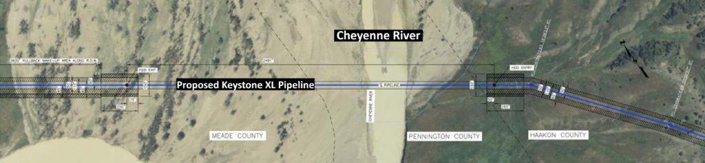
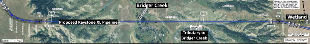
The photo above is an aerial diagram of the Cheyenne River crossing for Keystone XL, at least according to their 2009 permit application. Below are two more aerial diagrams from their 2014 certification:

The crossings of these and other water bodies will be done in one of two ways: first, by open-cut trenching; and second, in certain (and very few) areas known as High Consequence Areas, by horizontal directional drilling underneath the water body. Below are three engineering diagrams, from the same documents, of what the pipeline will look like underneath – at least, for now:
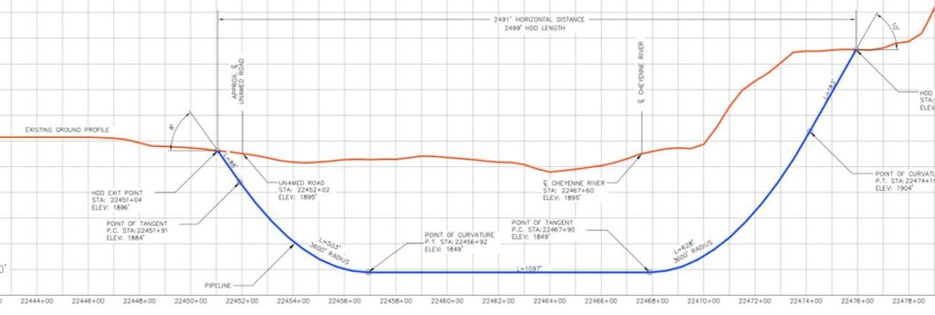
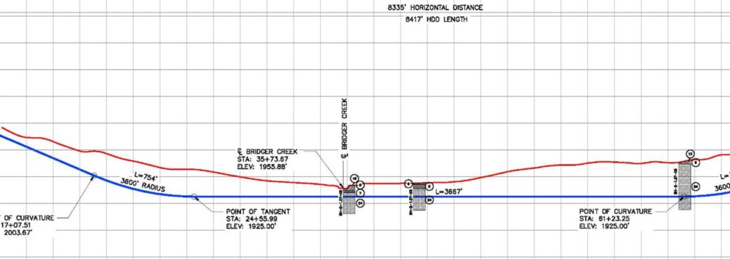
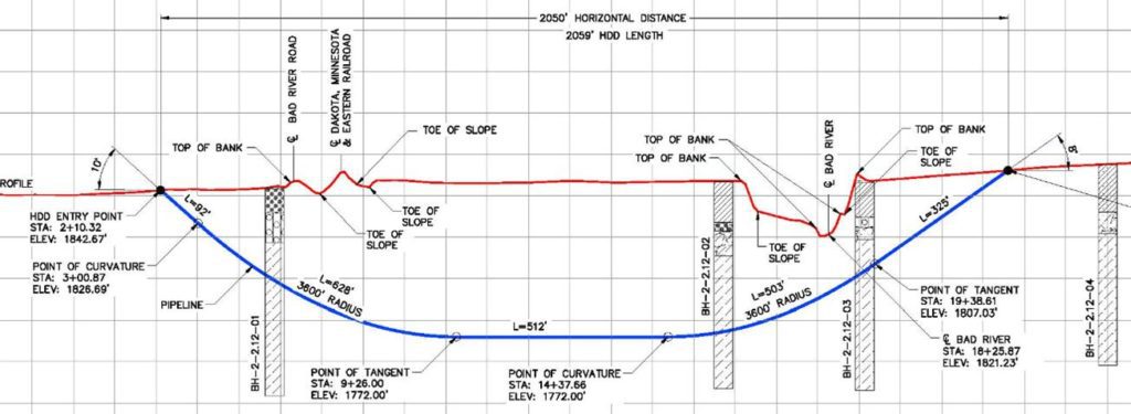
For now – that is important to note. These diagrams are not final, and we are not going to see the final diagrams, the final engineering plans for crossing our water bodies, before the Public Utilities Commission makes its determination on the permit. So whether or not TransCanada can comply with the requirements in the permit wont actually be known before the decision is made on the permit. Still following?
Another important piece of information to keep in mind. It isn’t just how the pipeline crosses under the creeks and rivers and streams. It is how those bodies of water shape the landscape, and how the landscape changes due to rain and other events. And how Keystone XL pipeline is affected by those changes.
For example, again according to Dr. Davis: In an event in Red Shirt, 2 million cubic yards of ground moved due to rain. TransCanada says they have safeguards like riprap in place to prevent any kind of land movement from damaging the pipeline. But Dr. Davis was clear: riprap wont prevent a slope failure of millions of cubic yards from occurring. And TransCanada has no plans for dealing with land movement of that scale.
South Dakota’s hydrology and geology are complex. The changes wrought to this landscape on an on-going basis should be respected. Bob Gough, attorney for the Intertribal Council on Utility Policy, has tried several times to bring into question the effect our dramatically changing landscape will have on the safety of the Keystone XL pipeline. TransCanada’s attorneys have, several times, shut down Mr. Gough’s questions.
So the question remains. What level of risk are we being asked to accept for TransCanada’s private profit?